|
|
|

|
-7.6
°C
 18 °F
18 °F
---
Feels like:
-11
24-hr difference
-6°C
|
|
24 HOUR TEMP TREND
|
| |
Today |
Yesterday |
| High: |
-4.7°C
12:00am |
1.1°C
1:38pm |
| Low: |
-7.7°C
3:02am |
-4.7°C
11:52pm |
| Min. Chill: |
-13
2:47am |
-10
11:56pm |
| |
High |
Low |
| Month: |
1.1°C
on the 2nd
|
-7.7°C
on the 3rd |
| Year: |
7.9°C
on Mar 9th
|
-36.1°C
on Feb 17th
|
| All Time: |
41.0°C
Aug 11,2018
|
-40.8°C
Jan 28,2004 |
| |
| AirlinkData: |
Temp-6.9°C
|
Humidity79%
|
| 2nd ISSData: |
Temp-7.4°C
|
Humidity85%
|
| TempestData: |
Temp0°C
|
Humidity0%
|
|
|
|
Current Gust:
6.4 km/h
1 Bft -
Light Breeze
|
|
Gust Last Hr:
13 kmh WNW
|
|
Avg. Last Hr:
5.2
|
|
Gust Today:
16.7 km/h
12:30am
|
|
Gust Month: 47 km/h April 1
|
|
Tempest Wind Data
Current: 0 at 0 km/h
Gust Today: 0 km/h |
|
|
|
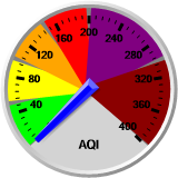
Air Quality Data
|
|
US EPA AQI: 8 - Good
Canadian AQHI: 2 - Low*
Particulate Matter Concentration µg/m3
PM1: 1.1 PM2.5: 2.0 PM10: 2.1
|
|
| Rain Today: |
0.0 mm
|
| Rain Today: |
0.00 in.
|
| Rain Rate (/hr): |
0.00 mm
|
| Rain Prev Hour: |
0.0 mm
|
| Rain Prev 6 Hrs: |
0.0 mm
|
| Rain Yesterday: |
0.0 mm
|
| Rain Prev Week: |
0.3 mm
|
| This Month:
x̄=22.1 |
0.3 mm
|
| This Year: |
12.2 mm
|
| Snow Depth: |
37 cm |
|
1 day of rain in April. |
|
|
|
|
|
Tonight

Chance of flurries
Min: -12°C
Thu, 3 Apr

A mix of sun and cloud
Max: 2°C
Night
Chance of flurries
Min: -13°C
|
|